From time to time, I will post examples of excellent student work. These posts will be titled, "Spotlight Work" as they are examples that are spotlight worthy. There is no schedule for these posts. I will post them when we as a class witness something we feel knocks our socks off.
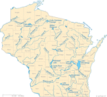
Our first featured work is from Chloe Williams! The whole class was amazed by Chloe's Wisconsin River map which shows the Wisconsin River and several tributaries. Chloe also showed the various landform regions in the state of Wisconsin and labeled them with a map key. Though my scanner does not show color, each landform region is color coded as well. We may have a future cartographer on our hands! Nice work Chloe!
Our first featured work is from Chloe Williams! The whole class was amazed by Chloe's Wisconsin River map which shows the Wisconsin River and several tributaries. Chloe also showed the various landform regions in the state of Wisconsin and labeled them with a map key. Though my scanner does not show color, each landform region is color coded as well. We may have a future cartographer on our hands! Nice work Chloe!
 RSS Feed
